Saturday 30 May 2015

Audax: Over the Hills & Far Away

Prologue - Coming Back from an L5/S1 Disc Herniation:

On Saturday the 31st of May 2014 I woke up in absolute agony, It was nerve pain like I had never experienced before. I was scheduled to partake in the Audax Brutal but Fair 300. Two weeks prior I had completed the Wing it West 200 and by end of the ride, the pinched nerve pain in my left leg felt better than it had in quite some time. Faced with the choice of either flopping back into bed or attempting the ride, I took the option of riding. Maybe a good choice, maybe not. Needless to say I suffered a lot that day but somehow managed to complete the ride. Interestingly enough, the back although constantly sore did slowly feel a little better as the ride progressed.

I knew the pain was horrendous but what was more worrying now was the fact that I was experiencing both numbness down the back of my entire right leg into my foot as well as weakness in my right leg. I booked in to see my Chiro Marty at Gladesville Healthcare on the Tuesday and he suggested I urgently seek an MRI for my lumbar spine. A week later I had the scans done and the results were certainly not what I was hoping for. I was diagnosed with a severe disc herniation at the L5/S1 level along with a Grade 1 Spondylolisthesis at the same location. This was a terrible result and Marty prepared me for the worst by easing me into the notion that I may never run again.

Below are my two MRI scans, the first one highlighting solids whilst the second one highlights fluids. If you look at the first image, you can see that the last disc above my sacrum is very clearly herniated. The gel from inside the disc has broken through the disc wall, mushrooming out and filling the canal that houses my spinal nerves. Its not until you look at the second image that you can really see the true extent of the damage. The thick white strip running down along behind my spine is the canal that houses the spinal nerves. Up the top it looks extremely healthy as there is lots of spinal fluid for the nerves to float in. When you get down to the site of the herniation the fluid is completely gone. The herniation has virtually filled the full width of the canal, crushing the nerves against the bone on the back side.

L5/S1 Disc is clearly mushrooming out in this image

Here you can see the extent that my spinal nerves were crushed

The Spondylolisthesis means that my L5 vertebra is not aligned correctly with the S1 vertebra that sits directly below it. Its only out by a few millimetres but its enough to put a lot of extra strain on the disc that sits between it. Marty said that it is quite likely that I have had the Spondylolisthesis since birth. The trouble is that it doesn't have any symptoms until it causes another problem. Although we never established the precise cause of the disc herniation, it is my suspicion that my lack of core strength has played a major role. The disc has slowly worn down over the last 28 years and I am sure that my love for pushing my body to its limit has probably accelerated the process!

In the few weeks following the injury the pain subsided slightly but the entire back of my right leg remained numb and my right calve muscle was weaker than ever. I had to keep my movements to a bare minimum as walking was very painful. Nerve pain would shoot from my back down through my glute and into my hamstring. The problem was that sitting or standing for extended periods would also enduce the same pain but with more of a throbbing sensation. Life was certainly a struggle. The first visit the Neurosurgeon was also particularly brutal as he told me straight up that unless I had some major surgery fusing my L5 & S1 vertebrae together that I would likely end up in a wheelchair eventually. Given the $50K pricetag for the surgery, I couldn't afford it even if I needed it so I went on the waitlist for the public system.

Fortunately I continued to improve ever so slowly over the coming month or so whilst waiting to see a different surgeon through the public system. He decided that it would be better to wait and see if it healed naturally as any surgery is potentially quite risky and the chances of having further problems later in life are extremely high. The recovery was frustrating and virtually the entire time it didn't feel like I was making any progress. It wasn't until I would do something like walk 100 metres up to the cafĂ© to grab a coffee pain free and realise that a few weeks prior the same activity would have left me in agony that I would even notice the improvement.

It only took a few weeks to get gingerly back onto the bike. Normally this would be highly inadvisable for anyone with my injury but for whatever reason the action of riding was therapeutic so Marty encouraged me to ease into it. After 3 months I started to go walking again but I was limping badly. The nerve impingement had stopped the ability for my brain to send a signal to the Peroneal Muscle and as a result it had shrank away to almost nothing. Even still just the freedom to go for a short walk in the bush again was a huge boost for my mental state! In September I started to slowly work my way back into some running. I started out with 100 metres and slowly worked my way up to 1 kilometre and so on. I was determined to do my traditional New Years Eve trail ultra, even if I walked the whole way. By the time we got to Christmas, despite still having some numbness in my hamstring and weakness in the peroneal muscle, I was almost completely pain free. Under Marty's guidance my recovery had truthfully been nothing short of miraculous. NYE eventually arrived and Paul accompanied me on what would be an emotional run for me. 8 hours and 20 minutes is by no means a good time for 47km but the fact that against all the odds I had actually managed to cover the distance was incredible!


Paul and I after our 2014 NYE Trail Ultra

2014 NYE Trail Ultra Photo Gallery:

2015 was set to be my comeback year! I had a few goals that I wanted to tick off the bucketlist, the big one being the Coast to Kosciusko Ultramarathon. Our family friend and someone whose adventures have been one of my inspiration's, Jan Hermann would likely be attempting a record 10th completion of the event! What a perfect time to be having a crack at my first! Completing the run on NYE had given me hope that it was possible so I set about working out which events I would use to qualify and started training. Progress was slow and it seemed to take forever to make any progress rehabbing the peroneal muscle. Training continued but I became frustrated with this muscle as it was really affecting my stride and although I wanted to push it to strengthen it I then started running the risk of compensating for it and causing other injuries.

Eventually I realised that I just need to be patient with it as the entire muscle basically needs to regrow from scratch. Fortunately it has strengthened enough for me to cycle without its weakness having any noticeable affect. I decided for the time being to put my running on the back burner and focus on cycling. With cycling I was now able to challenge myself again and that is after all what I have been craving. I set about training on the local steep climbs and built up my distance with a 200km recon of the 2015 Ride to Conquer Cancer route and then completing a solo 300km effort on the 2015 Brutal But Fair.

Over the Hills & Far Away:

So here we are, exactly 12 months on from my Disc Herniation. After the disappointment of putting all the hard work in to organise the ride last year and then missing out due to injury I was extremely excited to give it a crack this year. The fact that it was 12 months to the day since the injury meant it was also a pretty important milestone in my recovery. There were unfortunately only two of us taking part, Tim Hughes who was doing the 300 and myself attempting the 400. It had all the makings to a true epic!

In the weeks leading up to the ride my excitement had been growing more and more each day but for whatever reason when I got out of bed at 5am to start getting ready I was in a really bad state of mind. I think memories of the extreme difficulties that you face on a 400km ride had started coming back. I know it might sound obvious but its just such a long way!

We rolled out at 6:15am and settled into a nice easy pace. Watching the sunrise as we made our way through the maze of cycleways at Sydney Olympic Park was a real treat. We joined the M4 motorway and I took the lead trying to dodge the myriad of debris that covers the shoulder. As we were approaching the 24km mark Tim had a rear tyre blowout which was a real bummer. I already had doubts in my mind but now I was strongly considering pulling the pin and just riding the 300 as an unofficial ride. We got the tyre fixed and pressed on only to have it blow again from a second piece of glass 2 kilometres later! It was a massive blow and we were both now letting the negative thoughts creep in. On a ride like this you really need things to go your way in order to stay positive. We got the second puncture repaired and Tim declared that if he was to puncture again he was going to pull the pin. Wanting to salvage something from the day I said that if he punctured again I would withdraw from the 400 and accompany him on the 300. Being an Audax ride I had absolutely no obligation to stay with Tim but neither of us were really feeling it and eachothers company was likely to be the only thing that would turn that around.

I think Tim must have felt bad about the time wasted with the punctures as after the second one was repaired he got on the front and went full gas to make up time. We were absolutely hammering along covering kilometre after kilometre at 35-45km/h. I was struggling to sit behind him and still conserve energy for the task that lay ahead. We quickly reached the foothills of the Blue Mountains and started the climb up to Glenbrook. Due to the crazy amount of climbing that was to be faced throughout the day I knew it was absolutely imperative that I paced myself well or else I simply wouldn't have the strength left in the legs to even get up the very steep climbs later. Whenever the gradient wasn't too steep I was again following Durianrider's 'Spin to Win' motto. Whenever it was too steep to spin I would settle into a comfortable rhythm and then try to back it off even further. Slow and steady wins the race :)

We ticked off the townships one by one as we made our way deeper and deeper into the mountains. I have never ridden further than Springwood in this direction but fortunately I knew all the landmarks from the countless drives in the car that I have done. Around Katoomba I started to have a bit of a hunger flat which was the last thing I needed given the already fragile mental state. It was afterall quite a long way to the first checkpoint, Blackheath at the 106km mark. We eventually arrived there and after originally aiming for a quick stop I decided that it was wise to stay a little longer at get a decent meal in. The warm sausage roll and fruit pie washed down with a ginger beer really hit the spot. Its amazing how just getting some calories in can really boost your spirits. We both left feeling refreshed and excited for the countryside that we were heading towards.

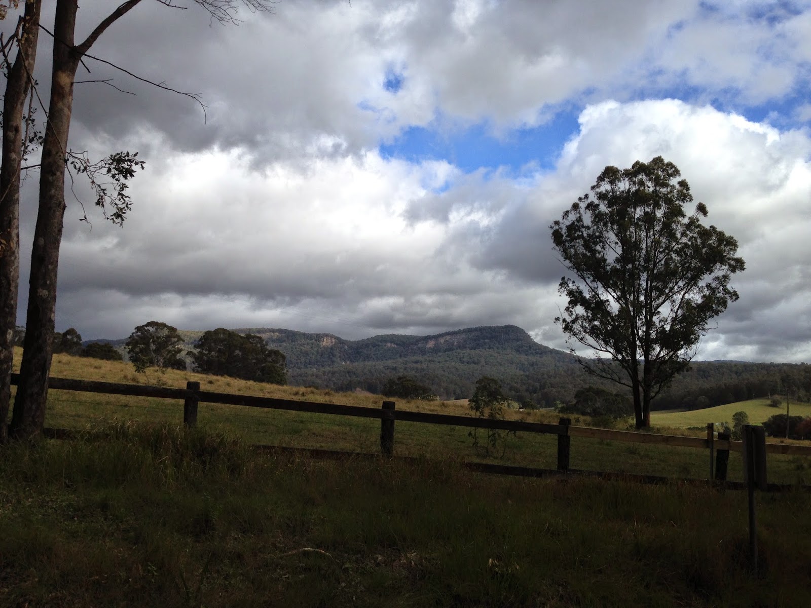
Its only a short trip from Blackheath to Mount Victoria which marks the western edge of the Blue Mountains. The fast descent down Victoria Pass was a blast and the views out over the Megalong Valley were fantastic. Swinging off the Great Western Highway and onto Cox's River Road marked the beginning of the real highlight of the ride. The countryside in this region and particularly in the Megalong Valley is absolutely stunning. The huge sandstone cliffs that the Blue Mountains are famous for stretched from right infront of us all the way back to the Narrowneck Plateau near Katoomba. In every direction lay beautiful rolling farmlands. Tim and I were absolutely loving it!
Stunning Views on Cox's River Road
After crossing over the Cox's River itself we got onto the first of two gravel sections for the day. I am a real sucker for the gravel on road bikes so this was really lifting my spirits! Most of the gravel was nice and hard packed but there was one short section with pretty loose gravel. Unfortunately this section also happened to coincide with a nasty little climb that was both covered in corrugations and with a gradient of 15%! It was a real brute and we decided to stop at the top for a quick breather. It was another good opportunity to admire the views.
Tim up ahead on the awesome gravel section Cox's River Road

Tim at the top of the nasty gravel climb. Stunning views of the
Megalong Valley in the background

At the top of the nasty gravel climb. Stunning views of the
Megalong Valley in the background

At the top of the nasty gravel climb. Stunning
views of the Megalong Valley in the background
After the rest stop we remounted and covered the final section of gravel before facing up to the nasty climb up to Jenolan Caves Road. Once on Jenolan Caves Road we were again treated to amazing views across the Megalong Valley. We made our way across to the small village of Hampton were the 300 & 400 course split. This was crunch time for me, I had to make a decision whether or not to push on. On the 300km course it was "only" 30km back to Lithgow which was very enticing. "F**k it!" I thought. "I have to give it a crack or I know I will really regret it later". I was sad to lose Tim's company as it had already been a long day and I still had another 260km to go! He would go on to complete the 300km shortly before 10pm.
Amazing views of the Megalong Valley from
Jenolan Caves Road

Tim and I at Hampton just before parting ways
I fired up the iPod for company and pressed onwards along Jenolan Caves Road. This part was more difficult than I had anticipated. It just dragged uphill for kilometre after kilometre. It was never really terribly steep but just slow going. As it was the afternoon most of the tourists had already arrived at the caves which meant that the road was nice and quiet. There was also quite a strong crosswind whenever the road got closer to the ridge line and at times it took quite a bit of concentration to keep the bike from being blown off the road. The descent down to Jenolan Caves was a real delight and as usual I was in complete awe of the surrounding mountains. The Jenolan River has carved out Hellgate Gorge over millions of years and its hard to even believe how steep the resulting terrain is. I eventually reached the bottom of the 8km descent and stopped to admire the Grand Arch. How often do you get to cycle through a cave? The whole area is really well done and I simply never get tired of the European chalet style Jenolan Caves House. After a few photos I quickly consumed some orange juice and a slice of apple crumble. The lady sitting at the table next to me asked "surely your not riding back up that hill today?". She just about fell off her chair when I said I was going all the way back to Sydney. I was happy with myself as including stopping to take photos I kept my break to under 20 minutes. I was anxious to get as much ground covered before darkness fell. I departed the Caves House a few minutes after 4pm for the monster climb towards Oberon.

The Grand Arch


Underneath the Grand Arch. The stairs in the background lead
up to the Carlotta Arch and Nettle Cave. Just to the right of the
stairs you can make out the opening of the enormous
Devil's Coach House

Jenolan Caves House
The climb out is properly brutal! The main part of it is "only" 3km long but it has an average gradient of 13%. There are many sections where it reaches 20%! Bloody hard on any given day but when it comes halfway through a 400km outing it really needs to be approached in the right way. I ground my way up slowly but surly but unfortunately its simply just too steep to take it easy. Even with my low gearing my cadence would have still only been 30-40rpm. I had to stop a couple of times for a breather on the way up the climb. The low cadence and increased torque going through the pedals was putting a fair bit of strain on my lower back. It was good as the muscles were doing their job and taking pressure off the spine itself but I didn't want to risk the muscles getting over tired. It was also a good excuse to get a few photos of how ridiculously steep the switchbacks are! I finally crested the climb and thinking back to memories of cresting the Kedumba Walls climb at the Mount Solitary Ultra shouted "Come On" as loud as I could! After the worst of it is over it drags on for a few more kilometres but at a much more manageable gradient. I decided to wait for the top of the climb before stopping for a leak. Even though it wasn't fully dark yet I also put my reflective vest on here and fired up my second rear light. I suspected that drivers wouldn't be expecting cyclists on this road at night so thought it best to resemble a Christmas tree as closely as possible.

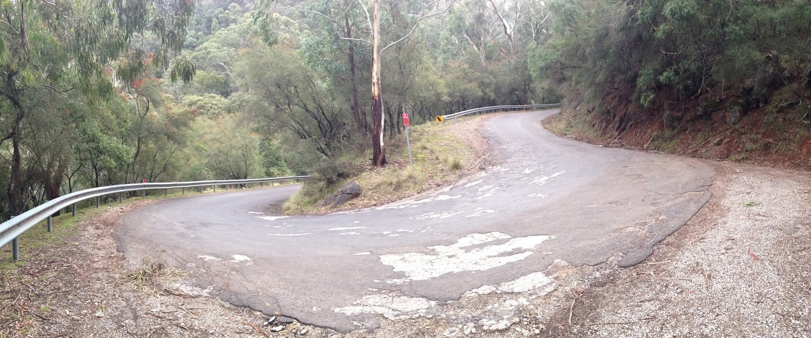
The second switchback on the climb out of Jenolan Caves


The fourth switchback on the climb out of Jenolan Caves
The run across to Oberon was quite enjoyable. The light was fading and there was quite a nice sunset to look at. It was a nice mental boost to see the lights of Oberon in the distance. I arrived at the town just before 6pm and decided to stop and put my leg warmers on. I was getting quite cold as it was only 3.5 degrees. I was now just shy of the halfway mark so decided to put an update up on my Facebook wall as I knew a few people would likely be keen to know how I was going. It was 50km of hilly terrain to get to Lithgow and some hot food. That was to be the motivation to keep me moving forward. The big climb out of Jenolan Caves had taken a fair bit out of me and this leg of the course was particularly tough. Whilst there was a lot of downhill to enjoy the also frequent uphills were steep. The legs were starting to feel pretty heavy in the saddle and then out of the saddle seemed to only last a few seconds before the lactic acid caused them to scream in pain. A switch had flicked in my mind though at some point since having crested the climb out of the caves. My mindset had moved from still unsure about the reality of finishing, firmly across to, I'm going to finish this bastard off no matter what it takes!

This mental focus was what I needed to get me home. I coasted and listened to music on the downhills but come the uphills I was staring down at the road, forcing my legs to keep the pedals turning over. The roads were super quiet which was fantastic, I would have only seen 10-15 cars on the entire journey across to Lithgow. I also saw a few kangaroos and a giant wombat whom quickly waddled off the road as I approached him. The pub at Tarana looked very inviting but I continued on my way and eventually made it to Lake Lyell. There were a number of people camped out by the lake with a campfire going for warmth which looked even more inviting than the pub! Cruising over the dam wall was fun and then I faced up to the final big climb before Lithgow. The kilometres ticked by and I got a few friendly cheers from cars as they passed me on the way up. Looking back down to the campfires along the edge of the lake was a fantastic site. Cresting the climb was certainly a relief and I enjoyed the mostly downhill run into Lithgow arriving just on 9pm. The hot chips from Maccas had never tasted so good and my first hit of caffeine for the day in the coke really hit the spot. I also enjoyed reading the words of encouragement from everyone on Facebook, they certainly got me pumped up and ready to go! I kept the break to under 15 minutes here which was good as It was getting late, I still had another 150km to go & I really just wanted to go to bed!
Wholesome Dinner :)
Leaving town I once again faced up to the darkness that comes with the country roads by night. I absolutely hammered it down the descent of Brown's Gap and was extremely grateful that I wasn't having to ride up it. There wasn't a single car on the road and I could barely even make out any lights in the farm houses. I was just in a little bubble created by my front lights. Eventually I got to Hartley Vale and the final long climb of the ride. The road turns to gravel here for a kilometre or two and it really brought a smile to my face. I was on the constant lookout for kangaroos as they were all over the road. The climb was steeper than I remember and I ground my way up and up until finally reaching the Darling Causeway. I remember being very excited and probably scaring some local wildlife with a few loud profanities. It was now almost 10:30pm and there was still another 130km to cover.

The next 70km to Penrith were mostly downhill. Now you would think that that is easy but when your not focusing on pedalling you mind tends to zero in on all of the pain that the rest of your body is feeling. My god there was a fair bit of that! I tried to coast as much as I could on the steeper descents but when it wasn't too steep it really made sense to pedal as it was going to get me home quicker. I made reasonable time and the legs were able to recover a little without the constant 10% climbs that I had been facing earlier in the day. Ticking off the towns again one by one was a good way to pass the time and eventually I made it to Warrimoo and swung off the Great Western Highway. The descent down Mitchell's Pass was fantastic and I was quite surprised to be passed by a police car on the way down. They gave me a friendly toot as they went by. From the bottom of the descent it was only a couple of kilometres across to the final checkpoint at Penrith. It was now 1am. 340km down, 60km to go! Paul encouraged me to channel my inner Fabio Aru and push for home. I think its safe to say that from about Oberon onwards, whenever the road was going uphill, the suffering on my face would have certainly matched or even bettered his. Thank god it was night time and no one was around to see it! :)
Fabio Aru suffering in the 2015 Giro d'Italia
The guy at the servo was pretty blown away when he signed my card and wished me best of luck for the rest of the ride. I smashed a can of coke and was back on my way in just under 10 minutes. I was keen to get off the roads here and across to the M7 cycleway. I have had my fair share of late night encounters with bogans in their commodores around Penrith and wasn't really in the mood for it. All I can say is 1am must be past their bedtime because it was a very pleasant ride. I wasn't holding anything back now and pushed as hard as I could. It was quite eerie on the M7 cycleway, there was not a single other rider out. Getting off the cycleway was great as I knew that I was almost in familiar territory again. There were a couple of steep climbs through Winston Hills but I just forced my way up them as best I could. At long last I made it to Windsor Road and instantly recognised where I was. It was a big relief and I cruised down the hill into Parramatta to join up onto the Parramatta Valley Cycleway. The cycleway was again deserted which was nice but I had to make one final stop. Pulling up under the lights of the Rydalmere ferry wharf with 390km in the bag I reached into my jersey pocket and pulled out the celebratory food. As usual my Grandma's Favourite Chocolate Custard was saved for the bitter end and it really hit the spot.
On a ride this epic... It would have
been rude not to :)
Full of energy with the music pumping in my ears I remounted one last time and went as hard as I could along the cycleway. All the landmarks were super familiar as I always run along here. I left the cycleway and made the final little climb up to Victoria Road whilst watching my total elevation gain for the day tick over 6500m! From here is was all downhill to the finish. I coasted my way home and pulled up outside my front door to stop the clock with a time of 21 hours, 56 minutes and 24 seconds.

What an incredible day. It was a stunning course but the sheer amount of climbing was brutal. Looking back on my cycling stats for the year this one ride actually made up 25% of my total kilometres for the year so far! Given that fact I would have to say that I had really great legs. They certainly felt like lead and/or screamed in pain for many many hours but they never feel apart completely. Nearly every part of my body was also sore and it made the second half a real sufferfest! But after all that pain comes the realisation that you have achieved something great and despite being alone on my front steps at 4 o'clock in the morning I had a pretty big smile on my face! What a way to mark 12 months since my injury and here's hoping that the recovery continues. It really was a true epic!

Strava GPS Data:

That moment when despite all the pain you realise
the epiccness of the journey you just completed!


About to switch off the Garmin... Crazy Stats!


Saturday 16 May 2015

Audax: Brutal But Fair 300 2015


I came into the ride feeling very undercooked due to a considerable number of other commitments over the last few weeks. I had managed to get in a 200km training ride the week before but it was almost pancake flat and I was pretty destroyed after it so needless to say I was a little worried at how this was going to turn out.

Leaving home shortly after 5am I made my way up to Hornsby via Brown's Waterhole. When I reached the start I was to discover that I was the only entrant in the ride. Initial thoughts were one of a little bit of despair as I was really hoping that in my undertrained state I would at least be able to draft behind people for some of the way to save the legs. Dave the ride organiser discussed the weather which was looking pretty ominous with some huge grey clouds rolling in! I departed Hornsby at 6:11 for a solo 300km epic!

I knew that in my current form I was going to have to be very careful to preserve the legs or else face the very real possibility of DNFing and being stranded in the Hunter Valley, neither of which seemed particularly appealing. My mantra for the day was Durianriders "Spin to Win" or usually in his colourful language's case, "Spin, to F**king Win". Every time the road turned even slightly uphill I repeated this to myself and switched down a few gears.

The first part of the ride was relatively uneventful until reaching the climb up to Mount White. The clouds opened up and it started to drizzle. Towards the top of the climb I was passed by two riders. I repassed them at the top as they were standing on the side of the road. Finally they caught me again as I was nearing the Calga Interchange. I asked them where they were off to and they said Somersby and then having seen my Audax "endurance cycling" jersey asked me the same question. I told them I was off to Cessnock at back. They both laughed and said "oh so just a short one then". The rain started to increase and they decided to turn back, Soft ;)

The next part of the ride was relatively straight forward. I stopped at Kulnura for a muffin and chocolate milk and then proceeded down towards Wollemi which is a real highlight of the route. The scenery in the valley is absolutely stunning and made for a really enjoyable run. I filled up the bottles with ice cold water at the Wollemi pub and then settled in for the cruise across to the lunch stop at Cessnock. Fortunately when I arrived there the whole town was no longer underwater and it was an absolute no brainer choosing a lunchstop. How could you possibily go past 'Old Mate's Bakery'? With 155km in the bag I savoured a can of coke and an apple pie before remounting to commence the return journey.

The beautiful scenery of the Wollemi Valley

How could you go past it :)


I absolutely love the next part of the route. The town gives way to rolling farmland and the views down to the Watagan Ranges to the south are always fantastic. The climb up Sandy Creek Road is a real treat and I got the phone out a couple of times to take a few snaps. From the top of the climb I hammered it down the descent and finally made the proper turn south and towards home onto Branxton-Toronto road.

Sandy Creek Road Climb
Stunning view South towards the Watagan Ranges from the Sandy Creek Road climb

Almost at the top of the Sandy Creek Road climb
Finally at the top and enjoying the scenery
across the valley

As soon as I turned south I was instantly hit with a fierce headwind. My heart sank, I was starting to feel pretty buggered and was not sure I was capable of the 150km return to home with a headwind the entire way. It had rained the entire way from Mount White to Wollembi but since then it had been really nice overcast conditions but there were some serious storms raging near Watagan Gap which I was heading straight for. Its a tough climb with a long section about 10%. Unfortunately I could 'spin' on this one so I just went as easy as possible. Cresting the top I plummeted back down the other side and continued south. I was extremely pleased to discover that the headwind was only localised with strong wind currents flowing through the gap in the mountains at Watagan Gap. The rain started to fall heavily for about 5 minutes and then stopped. This was the start of a very frustrating weather pattern that would last for the rest of the ride. It would seem to wait just long enough for me to dry out (maybe enjoy 30 minutes of being dry if I was lucky) and then piss down for 5-10 minutes just resoak me.

Looking South towards the storm over Watagan Gap

The journey south towards Wyong was pretty uneventful and despite the large traffic volumes everyone bar one truck was very courteous leaving me heaps of space as they overtook. I still felt surprisingly ok and the back and neck weren't overly sore which allowed me to get down on the aerobars on the flat sections and tick the kilometres off that little bit faster. After the short section through the Yarramalong Valley it was onto the Pacific Motorway and I absolutely hammered it down to Ourimbah for my next food break with 239km in the bag. I desperately wanted some salty food after all the sugar so went the staple salt and vinegar chips and then remounted for the big climb up Dog Trap Road.

This was another fantastic section, the road is quite rainforesty and the lyrebirds where chirping away. It was reasonably light at the bottom but by the time I reached the top it was almost fully dark. I pulled over on the side of the road and put on my reflective vest and then started the rest of the grind up to Peats Ridge. This was the final stop with 261km covered. I was pretty quick here and back on my way within 5 minutes or so for the mostly downhill run to the Mooney Mooney Bridge. The stars were now out in force and I was having a total blast. It doesn't get much more epic than riding down a pitch black country road with millions of stars overhead and Ayreon's Amazing Flight pumping through your earphones!

I crossed over the Hawkesbury river and absolutely crawled up to Pie in the Sky. I made it but not without some strong words to myself throughout the climb. Lucky it was night time and no one was around or there could have been some strange looks. The final run into Hornsby is undulating and I stuck to the mantra on each of the little uphills. I ticked off each train station along the way and finally rolled into the Hornsby Police Station at 9:05pm for a time of 14 hours and 54 minutes!

Celebratory Grandma's Favourite
Chocolate Custard

I didn't waste a lot of time, only enough to savour a celebratory Grandma's Favourite Chocolate Custard before jumping on the bike one last time. The cruise home was nice but I sure as hell was happy to get home and power down the Garmin with a total of 333km and a pretty respectable 3,924m of climbing for the day. Although a little slower than previous attempts at this course I am really happy with my effort. I was completely solo the entire way so I had to earn every kilometre. I was also very undertrained for an outing of this magnitude so I am really please with the way I managed to pace myself almost perfectly. I certainly need to hit the hills over the next two weeks but I feel like the Jenolan Caves 400 at the end of the month has gone from impossible to doable :)

Strava GPS Data:

The trusty steed finally about to get some rest after
another 333km epic!

Excellent choice for a post ride beer :)

Tuesday 7 April 2015

The Three Peaks Attempt - March 2015

The Three Peaks is one of the classic bushwalking challenges in the Blue Mountains. The route starts in Katoomba and travels south into the Kanangra Wilderness Area. Here you climb and descend three mighty peaks; Mount Cloudmaker, Mount Paralyser & Mount Guouogang. Much of this section is completely off trail and even when there is a trail it’s usually faint and/or overgrown. There is history of this challenge going back as far as the 1960’s and it’s been something that I have really wanted to have a crack at for a long time!

Planning had been underway for quite some time in the lead up to our attempt with various potential team members but in the end it was just Mikey and I that were able to make the start. We met at a pub in Strathfield for dinner on the Friday night. We both could barely contain our excitement as neither of us had ever attempted anything like this before. We got through the meal quickly and hopped in Mike’s car for the drive up to Katoomba. The rain started to settle in as we made our way into the lower suburbs of the Blue Mountains and by the time we passed Woodford it was starting to get foggy. By the time we got to Katoomba the fog was so thick that we needed the gps to get down to Narrowneck as we couldn’t even make out the street signs. We parked the car in a side street and offloaded some unnecessary gear from the packs before getting underway shortly after 9:30pm. Leg one of the journey was intended to be about 30 kilometres and have us camping at the Cox’s River between 3-4am for a couple of hours sleep.

Leaving the streets of Katoomba, our walk would take us south onto the expansive Narrowneck Plateau. We quickly left the safety of the streetlights behind us and plunged into darkness. Thick fog with constant rain and occasional wind gusts made for really tough conditions. The fog dissolved any ambient light available from the moon so our visibility was reduced to about 5-10 metres. We felt like we were in a little bubble and a lot of the time couldn’t really see any more than a metre past the edge of the firetrail. Normally a very scenic walk along Narrowneck became a game of trying to work out where we were based solely off of my memory of the firetrail itself. In the end we walked straight past the huge firetower without even realising it! It wasn’t until we reached the pebbly section of trail and the wind really picked up that we knew we were getting close to Clear Hill. Clear hill normally has excellent views across to the Megalong Valley but that night it was like looking into the blackness of oblivion!

After approximately 3 hours we made it to Clear Hill at the very southern tip of the Narrowneck Plateau and swung off the firetrail to join the single track down to Tarros Ladders. About halfway down the descent we stopped in a little cave for a 10 minute chocolate break. Most of the descent is reasonably easy with a few short scrambles but the best part it a set of climbing spikes which take you down the final 10 metre cliff.

We were both looking forward to the challenge of Tarros Ladders in the dead of night and wasted little time once we arrived at the top. It was a quite enjoyable experience but we did need to be fairly careful as the spikes were a little slippery in the rain. From Here we traversed over the ridge of Mount Derbert and down into the clearing at Medlow Gap. After less than a kilometre of walking on the White Dog Ridge Firetrail we made the turn onto the Katoomba to Kanangra (K2K) walking trail. This was where our plans started to slowly but surely unravel.

Up until this point we had been making pretty good time and were only slightly behind were we wanted to be. Once on the K2K walking track however our visibility was never more than about 5 metres. The track is very overgrown in some places which meant that even staying on the path was difficult! The rain although not heavy was constant so between that and forcing our way through what seemed like an endless number of damp shrubs we both got completely soaked. Leeches were also very common in the marshes around Mobb’s Soak. I remember making a comment to Mikey at about 3am that I was glad it wasn’t pissing down. This promptly had us both in stitches for the next 10 minutes or so as even if we went for a swim we couldn’t have possibly been more soaked than we already were! We quickly got further and further behind schedule and by about 4am with a little over 20km covered we knew that we would have to walk all night to even have a chance at a successful attempt. We passed a few little campsites and stopped briefly at each one trying to figure out if we should stop for a quick sleep or not. At that time of the night we were both wired but deep down the body is keen for sleep so making even a simple decision is a struggle. Finally after approximately 25km we found a nice saddle near the top of Mount Yellow Dog and Mikey made the executive decision that this would be where we stashed our packs.

Proceeding with only day packs the going was much easier and we made good progress on the descent to the Cox’s River. The world slowly began to expand as first light approached and we were treated to some fantastic but imposing views of the surrounding mountains. It was really only at this point that you start to fathom the true scale of the mountains in this area. At long last we finally reached the Cox’s River shortly after 7am, it had taken us almost 10 hours to cover the 30 kilometres.


First light on the descent of Mount Yellowdog. Mount Konangaroo
on the far side of the valley - 28km mark


Finally at the Cox's River after walking all night - 30km mark


Crossing the Cox’s River was quite enjoyable but we only got to savour the flat terrain for a few hundred meters. The next big challenge would be the ascent up Mount Strongleg. It was a nasty climb with extreme gradients. It was so steep in some places that we were using the trees and shrubs to pull ourselves up the slippy and loose terrain. Finally after cresting Mount Strongleg the gradient eased off but it was still pretty slow going as the track was often overgrown with shrubs. There were a number of rocky outcrops where we were treated to some excellent views across the valley towards Mount Paralyser (the second peak). The final push to the summit of Mount Cloudmaker seemed to drag on forever but we finally arrived at about 11:30am and slumped down for some breakfast. It was our first proper food since dinner some 17 hours beforehand and as usual Mikey didn’t disappoint with a blueberry & chia pudding!


Incredible view accross the Valley to Mount Paralyser from near the top of Mount Strongleg - 33km mark
 

Mikey had been hurting for a while and had been dropping subtle hints by suggesting cutoff times to reach certain spots. Over the course of the ascent we had both decided on 11am for the Cloudmaker Summit and we unfortunately missed it by 30 minutes. I must say, my disappointment in failure didn’t last particularly long. It was obvious that with better conditions we would have been several hours ahead of where we were and with the tiredness creeping in we were likely to only get further and further behind schedule. This meant that we would have almost certainly been trying to descend down off Mount Guouogang in the dark with no track to follow. Considering the mental fatigue we would have been carrying after many more hours on the move it was more than sensible to pull the pin and turn back.

We spent half an hour or so at the summit signing and reading the logbook. It was incredible to see that there hadn’t been a single visitor there in almost 2 months. It really highlighted how remote and untouched this wilderness is and it was and absolute pleasure to have it all to ourselves. After a while we dragged ourselves up and started the long descent back to the Cox’s River. I had been firing on adrenalin on the climb up to Cloudmaker and now that we were turning back my energy levels certainly took a pretty serious dive. It was however nice knowing that we could take our time a bit more on the descent. We just plodded along and enjoyed the views wherever they were available. We also stopped briefly at the Dex Creek campsite which is a beautiful high camp and well worth another visit. Neither of us were enjoying the steeper sections as the legs were getting pretty buggered at this point. It was really enjoyable looking at the different types of trees and shrubs and how they seemed to vary so quickly depending on the elevation and exposure to the elements.


Finally at the summit caine of Mount Cloudmaker! - 39.5km mark


Mount Cloudmaker Logbook - 39.5km mark
 

Eventually we made it back to the Cox’s River and all that was left between us and camp was the final 5km climb up to the top of Mount Yellow Dog. We had a short break by the river while we fired ourselves up for the climb. Once we got started I was determined to not stop until we reached our packs. The light slowly faded away as we climbed and the ascent seemed to go on forever. There were a number of little saddles on the ridge which neither of us remembered from the previous night so there were several times when we thought we had made it only to have to keep climbing. We eventually reached our campsite shortly after nightfall. It had taken us about 22 hours to cover the 55 kilometres!

We quickly got the tent setup and somehow managed to get a fire going despite all the timber being very damp. We boiled some water for hot tea whilst quickly trying to dry our sleeping bags out as we could hear what sounded like a pretty big storm rolling in. At long last we got into our sleeping bags and enjoyed our quinoa monk bowl dinner, Mikey had delivered the goods yet again! We reminisced over the adventure so far and what things we could possibly have changed to create a successful outcome whilst enjoying a whisky nightcap. The rain settled in yet again and despite falling asleep very quickly it was a pretty rough night. I awoke not long after midnight to discover a puddle in the tent only inches from my head. We had set the tent up in a bit of a hurry and positioning of the pegs for the fly wasn’t ideal. Under the weight of the rain water it was resting on the inner wall of the tent which was causing the problem. I got out of the tent in the rain with my headlamp and somehow managed to get it fixed. Fortunately the adjustments worked and after that we were able to relax and get a few decent hours of sleep.


Our high camp in a saddle near the top of Mount Yellowdog - 55km mark


Our high camp in a saddle near the top of Mount Yellowdog - 55km mark
 

We had a slow start the next morning as it was still raining and it was certainly hard to be motivated to get moving again. After breakfast in our sleeping bags we got everything packed up and departed camp about 9am. The fog was much milder than the Friday night but the rain still fell consistently so we were quickly re-saturated. Despite this we made fairly steady progress along the K2K trail all the while being on the constant lookout for leeches. It was a big relief to reach the White Dog Ridge Firetrail knowing that we only had one serious climb up Mount Derbert left between us and the Tarros Ladders. Whilst only short, the climb up to the Mount Derbert ridge is brutally steep and we took it at a snail’s pace. Cresting the ridge we were stunned to not only see a gap in the clouds but actually some direct sunlight for the first time! The last section of this trail leading up to Tarros Ladders is pretty smooth and one of my favourites so we really enjoyed it. We were also excited about the prospects of the views from Narrowneck which would make for a nice walk back to the car. It was a relief to be ascending the climbing spikes with light this time and we got some cool footage with the GoPro. By the time we had gotten to the top of the spikes the sun that was out some 30 minutes earlier was well and truly gone and all that could be seen was white fog in all directions.


Nothing but fog to look at from the top of the Tarros Ladders - 65km mark
 

Once back on the Narrowneck Firetrail the rain quickly closed in. Leaving Clear Hill behind us we made the climb up to the fire tower for a final chocolate break. After this it was simply a matter of ticking off the kilometres back to the car. Slowly but surely we made progress along the plateau and although we couldn’t see too far, the visuals of the fog swirling over the cliffs was pretty spectacular. It was great to see some familiar landmarks as we closed in on the finish. Finally at about 3pm we reached the safety and comfort of the car. Our adventure had lasted over 42 hours and we had covered 78.5 kilometres with a staggering 3800 metres of vertical climbing and descending!!!


Finally back at the car!!!


As mentioned previously there was simply no regret that we didn’t make it to all three peaks. It was such an incredible experience between two mates in such an epic landscape. It’s funny to look back on how our friendship begun some 15+ years ago and see how far we have come. It all started out with late nights playing video games and over the years our interests have evolved to finally arrive at an adventure like this. The other exciting thing about not completing the challenge is that there is now more desire than ever to give it another go. We will reassess what went wrong and what can be changed and launch another assault in the future. Perhaps the best thing of all is that you never forget an experience like this. It’s the sort of adventure we will both be able to look back on in 50 years and although the finer details will probably be long forgotten there will still be that lingering sense of epicness that remains!!!

Strava GPS Data
Full Photo Gallery

For more info on the route if your interested in giving it a go, check out Ashley's Burke's brilliant website:


                                                                                  Epic Video of the Hike!